How to Read a Sectional Chart for the Part 107 Test
Last updated October 4, 2026
To read a sectional chart for Part 107, work out four things for the spot where you want to fly: the airspace class and its floor and ceiling, what the nearest airport’s data block says, which obstacles and terrain are around, and whether any special use airspace or flight restriction applies. Chart altitudes are in feet above mean sea level (MSL) unless marked otherwise, while your drone limits are above ground level (AGL), so many chart questions come down to one symbol and one subtraction. Below, we walk through each item on two extracts from the current Seattle sectional.
Beginning October 26, 2026, the Part 107 test (Unmanned Aircraft General - Small, UAG) adds image-based questions from the latest sectional charts that are not in the testing supplement (FAA Airman Testing Community Advisory, September 2026, p. 6). The Remote Pilot ACS lists what you must know: airspace classes B to G (UA.II.A.K1), special use airspace (UA.II.A.K2), other airspace areas such as TFRs (UA.II.A.K3) and charts as a source of airport data (UA.V.B.K6a) (FAA-S-ACS-10B, pp. 9 and 15).
Symbol meanings below come from the FAA’s Aeronautical Chart Users’ Guide, July 9, 2026 edition (“Chart Users’ Guide”).
The sectional at a glance
| What you see | What it means | Source |
|---|---|---|
| Blue numbers such as 100 over 30 | Class B: ceiling over floor, in hundreds of feet MSL (10,000 over 3,000) | Chart Users’ Guide, p. 16 |
| Magenta numbers such as 64 over SFC | Class C: same format. SFC means the surface. A “T” ceiling means up to, but not including, the Class B above | Chart Users’ Guide, p. 16 |
| Dashed blue line, number in a dashed blue box | Class D, ceiling in hundreds of feet MSL. A minus sign means “from the surface to, but not including” | Chart Users’ Guide, pp. 16 and 27 |
| Dashed magenta line | Class E surface area (controlled airspace from the ground up) | Chart Users’ Guide, p. 17 |
| Shaded magenta band | Class E floor at 700 feet AGL on the shaded side | Chart Users’ Guide, p. 17 |
| Shaded blue band | Class E floor other than 700 feet AGL next to Class G | Chart Users’ Guide, p. 17 |
| Blue airport name and data | Airport with a control tower (magenta means no tower) | Chart Users’ Guide, p. 15 |
| Large bold figure such as 28 | Maximum Elevation Figure: 2,800 feet MSL | Chart Users’ Guide, p. 12 |
| Two figures such as 507 over (303) | Obstacle: top in feet MSL, height AGL in parentheses | Chart Users’ Guide, p. 11 |
| P-, R-, W- or A- plus a number, or a named MOA | Special use airspace | PHAK, pp. 15-3 to 15-4 |
Step 1: Airspace, floors and ceilings
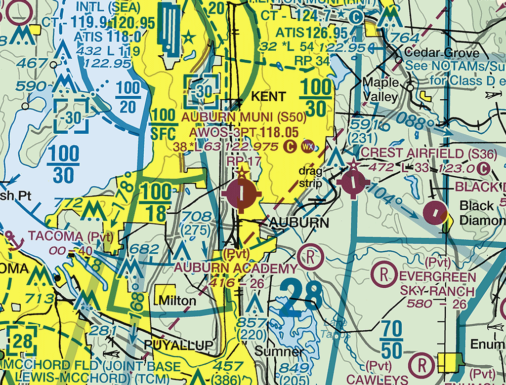
Extract from the FAA Seattle sectional chart, September 3, 2026 edition. For training only, not for navigation.
The blue figures on this extract belong to the Seattle Class B. Class B floors and ceilings are printed in blue, in feet MSL with the last two zeros left off (Chart Users’ Guide, p. 16). So:
- 100 over SFC (west of Kent): Class B from the surface up to 10,000 feet MSL.
- 100 over 30 (east of Kent): Class B from 3,000 feet MSL up to 10,000 feet MSL. Below 3,000 feet MSL you are under this shelf, not in it.
The dashed blue boxes containing -30 are Class D ceilings: from the surface up to, but not including, 3,000 feet MSL (Chart Users’ Guide, pp. 16 and 27).
You need prior authorization from Air Traffic Control (ATC) to fly in Class B, C or D airspace, or within the lateral boundaries of a Class E surface area designated for an airport (14 CFR 107.41). Class G runs from the surface up to the base of the Class E above it (Pilot’s Handbook of Aeronautical Knowledge, FAA-H-8083-25C, p. 15-3), so where nothing else is charted, a drone at 400 feet AGL under a 700-foot floor is in Class G and needs no ATC authorization.
MSL versus AGL. Unless a chart says otherwise, its altitudes are MSL (Chart Users’ Guide, p. 6). AGL = MSL minus ground elevation, taken from a data block or an obstacle’s figures (Step 3).
Step 2: Airport data blocks
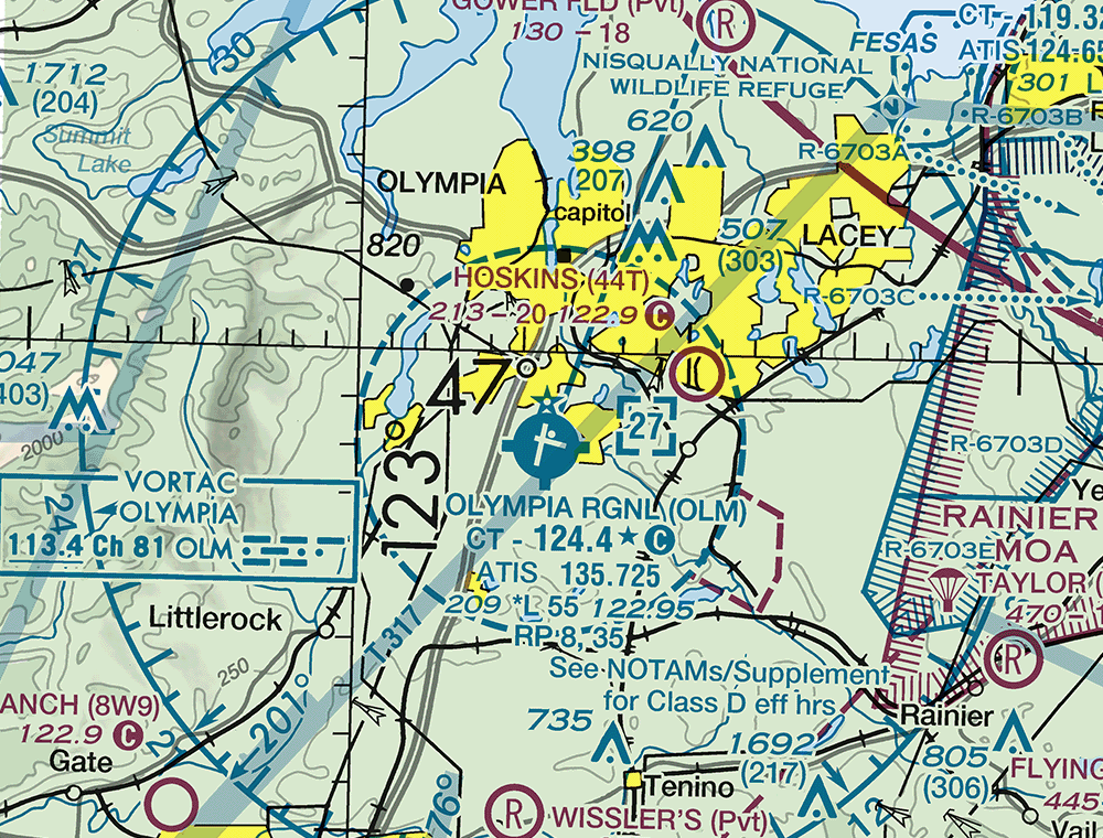
Extract from the FAA Seattle sectional chart, September 3, 2026 edition. For training only, not for navigation.
Airports with a control tower and their data are shown in blue; all others are magenta (Chart Users’ Guide, p. 15). Here is how to decode the Olympia Rgnl (OLM) block, line by line (Chart Users’ Guide, pp. 15-16):
- CT - 124.4 ★ C: control tower frequency 124.4. The star means part-time. The circled C follows the Common Traffic Advisory Frequency (CTAF), so 124.4 is also the CTAF, used when no tower is operating (Remote Pilot Study Guide, FAA-G-8082-22, p. 40).
- ATIS 135.725: Automatic Terminal Information Service, a looped recording of local weather and other airport information (Remote Pilot Study Guide, p. 67).
- 209 *L 55 122.95: field elevation 209 feet MSL; *L means runway lighting has limitations, so check the Chart Supplement; 55 is the longest runway, 5,500 feet; 122.95 is the UNICOM (aeronautical advisory station).
- RP 8, 35: runways 8 and 35 use right-hand traffic patterns.
- The note See NOTAMs/Supplement for Class D eff hrs tells you the Class D is not in effect around the clock (Chart Users’ Guide, p. 16).
The dashed blue circle is the Olympia Class D, and the 27 in the dashed blue box is its ceiling: 2,700 feet MSL.
Now compare a non-towered airport. Hoskins (44T), north of Olympia Rgnl, is magenta: 213 - 20 122.9 C means elevation 213 feet, a dash where the lighting code would be (no runway edge lights), a longest runway of 2,000 feet, and a CTAF of 122.9 (Chart Users’ Guide, p. 15). On the first extract, Auburn Muni (S50) shows AWOS-3PT 118.05 (automated weather), a CTAF of 122.975, a circled WX for a weather camera, and RP 17 (Chart Users’ Guide, pp. 15-16).
Near any airport, you may not interfere with operations and traffic patterns at any airport, heliport or seaplane base (14 CFR 107.43).
Step 3: Obstacles, terrain and maximum elevation figures
Obstacles. The blue figures give the top of an obstacle in feet MSL, with its height AGL in parentheses below (Chart Users’ Guide, p. 11). Near Lacey on the Olympia extract, 507 (303) means the top is 507 feet MSL and the obstacle is 303 feet tall, so the ground at its base is about 204 feet MSL. Under Part 107 you may fly higher than 400 feet AGL only within a 400-foot radius of a structure and no more than 400 feet above its top (14 CFR 107.51(b)), so near this one that limit is 703 feet AGL.
Sectionals typically show man-made obstacles more than 200 feet AGL, or more than 299 feet AGL in yellow city areas (Chart Users’ Guide, p. 11), so shorter ones may be missing, and new towers may not be on your chart yet. Guy wires can extend about 1,500 feet out from a tower and are very hard to see (Remote Pilot Study Guide, pp. 69-70).
Maximum Elevation Figure (MEF). The large 28 southeast of Auburn is an MEF. It is the highest elevation in that quadrant, terrain or obstacle, rounded up to the next 100 feet with the last two digits dropped, so 2,800 feet MSL. A quadrant is bounded by the ticked lines every 30 minutes of latitude and longitude (Chart Users’ Guide, pp. 12-13). Read it as a terrain and obstacle height, not an airspace limit.
Step 4: Special use airspace and TFRs
| Type | Charted as | What it means for you |
|---|---|---|
| Prohibited area | P plus a number (P-40, Camp David) | No flight without permission from the using or controlling agency (14 CFR 107.45) |
| Restricted area | R plus a number (R-6703A to E on the Olympia extract) | Often invisible hazards such as artillery firing (PHAK, p. 15-3). Permission needed (14 CFR 107.45) |
| Warning area | W plus a number | From 3 NM off the US coast, may hold hazardous activity (PHAK, p. 15-4) |
| Military operations area (MOA) | A name, not a number (Rainier MOA on the Olympia extract) | Separates military training from IFR traffic (PHAK, p. 15-4). Keep a sharp lookout |
| Alert area | A plus a number | Heavy training or unusual flying; all pilots share collision avoidance (PHAK, p. 15-4) |
| Controlled firing area | Not charted | Activity stops when an aircraft approaches (Chart Users’ Guide, p. 17) |
On the Olympia extract, the restricted areas have a blue hatched border and Rainier MOA a magenta one: prohibited, restricted and warning areas are charted in blue, alert areas and MOAs in magenta (Chart Users’ Guide, p. 30). Times, altitudes and controlling agencies for special use airspace are listed in a table on the chart, and no NOTAM is issued to announce those permanently listed times (Chart Users’ Guide, p. 20).
TFRs are mostly not on the chart. A temporary flight restriction (TFR) is a type of NOTAM, and only TFRs related to national security are charted (Chart Users’ Guide, p. 18). It is your responsibility to know about TFRs where you fly, and the FAA’s tfr.faa.gov site is one way to check (PHAK, p. 15-6). Part 107 requires you to comply with the flight restriction rules in 14 CFR 91.137 through 91.145 and 99.7 (14 CFR 107.47) and to assess local airspace and any flight restrictions before every flight (14 CFR 107.49(a)(2)).
Step 5: Latitude and longitude
Parallels of latitude run east and west and measure degrees north of the equator; meridians of longitude run pole to pole and measure degrees east or west of the Prime Meridian (PHAK, p. 16-3). On the Olympia extract, the long black line labeled 47 is the 47° N parallel and the line labeled 123 is the 123° W meridian. Olympia Rgnl sits just south of 47° and just east of 123°, so it is a little under 47° N and a little under 123° W, because west longitude grows going west.
A routine for any chart question
- Find the place named in the question.
- Identify the airspace there from line color and style, and read its floor and ceiling.
- Convert between MSL and AGL using the field or ground elevation.
- Read the nearest data block for frequencies, elevation and patterns.
- Scan for special use airspace, obstacles and boxed notes.
- Apply the matching rule (14 CFR 107.41, 107.43, 107.45, 107.47 or 107.51).
Try it: an original example
Using the Olympia extract, about how high above the airport does the Olympia Rgnl Class D airspace reach?
A. About 2,500 feet B. About 2,700 feet C. About 2,900 feet
Answer: A. The 27 in the dashed blue box is the Class D ceiling, 2,700 feet MSL (Chart Users’ Guide, p. 27). The data block gives the field elevation as 209 feet. 2,700 minus 209 is about 2,500 feet, the usual Class D height above the airport (PHAK, p. 15-2). B reads the MSL figure as height above the airport. C adds the elevation instead of subtracting it.
Common mistakes
- Reading Class B and C figures as AGL. They are MSL.
- Swapping floor and ceiling. The top number is the ceiling.
- Mixing up the dashed magenta line (Class E surface area, authorization needed) with the shaded magenta band (Class E from 700 feet AGL, Class G below it).
- Treating the MEF as an airspace label.
- Assuming the chart shows every TFR.
- Using an old chart. Sectionals are updated every 56 days (Chart Users’ Guide, p. 23), so check the effective dates (p. 6).
How to prepare
- Read Chart Users’ Guide pages 10 to 20 and 23 to 31 with a current sectional open.
- Pick five airports near you. Decode each data block and name the airspace from the surface to 400 feet AGL.
- Practice by topic: airspace classification and operating requirements and operations (airport data).
- Learn the rules that turn a symbol into an answer in regulations.
On test day
As of October 2026, the printed testing supplement stays at test centers until the FAA sets and announces a removal date (Airman Testing Community Advisory, September 2026, p. 5). It includes a sectional chart legend (Airman Knowledge Testing Supplement, FAA-CT-8080-2H, Legend 1). The FAA says images in live questions cannot be previewed and that applicants will have the measuring tools they need, with details of on-screen tools to come (p. 5). More in Part 107 test changes on October 26, 2026.
Common questions
Are sectional chart altitudes MSL or AGL?
MSL, unless the chart says otherwise (Chart Users’ Guide, p. 6). Class E floors shown by shaded bands, such as 700 feet, are AGL (p. 17).
Do I need ATC authorization to fly under a Class B shelf?
Not for the Class B if you stay below its floor. But check what lies underneath: Class C, Class D or a Class E surface area there still needs authorization (14 CFR 107.41).
Do I have to memorize every symbol?
No. Focus on the items the ACS names (airspace, special use airspace, airport data) and look up the rest in the Chart Users’ Guide.